
1) The Bab El Mandeb is the water way between Djibouti and Yemen it is a water that connects the Red sea to the gulf of Aden.
The Goda mountains are also located in Djibouti. They extend 1,750 meters above sea level and are the countries most vegetated area.
2) lake Assal is one of the countries few lakes and is located in central eastern part of Djibouti. The lake's length is close to 12 miles long and the width is just below 4 and 1/2 miles. There is also the Abbe lake that lies on the border of Djibouti and Ethiopia. The lake is split almost down the middle, it has a surface area of 173.7 sq miles. The landscape around the lake resembles that of the surface of the moon.
Mauritania has a generally flat landscape with vast plains that are punctuated by the occasional ridge or cliff-like outcropping.
Bisecting the plains in the center of the country are a series of sandstone plateaus giving way to spring-fed oases.
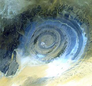
The most prominent feature of this region is the Guelb er Richat, also known as the Eye of the Saraha, which is a deeply eroded dome consisting of a variety of intrusive and extrusive igneous rocks.
Three-quarters of the Mauritania landscape is desert or semidesert, and as a result of severe drought the arid land has been expanding. There are no significant lakes or rivers.
The Goda mountains are also located in Djibouti. They extend 1,750 meters above sea level and are the countries most vegetated area.
2) lake Assal is one of the countries few lakes and is located in central eastern part of Djibouti. The lake's length is close to 12 miles long and the width is just below 4 and 1/2 miles. There is also the Abbe lake that lies on the border of Djibouti and Ethiopia. The lake is split almost down the middle, it has a surface area of 173.7 sq miles. The landscape around the lake resembles that of the surface of the moon.
Mauritania has a generally flat landscape with vast plains that are punctuated by the occasional ridge or cliff-like outcropping.
Bisecting the plains in the center of the country are a series of sandstone plateaus giving way to spring-fed oases.
The most prominent feature of this region is the Guelb er Richat, also known as the Eye of the Saraha, which is a deeply eroded dome consisting of a variety of intrusive and extrusive igneous rocks.
Three-quarters of the Mauritania landscape is desert or semidesert, and as a result of severe drought the arid land has been expanding. There are no significant lakes or rivers.
